Akron sits atop a complex sequence of glacial tills, outwash sands, and lacustrine silts deposited during the Wisconsinan glaciation. The buried valley of the ancestral Cuyahoga River cuts through the city center, filled with up to 150 feet of soft alluvium and organics that amplify ground motion differently than the surrounding till uplands. With a population of roughly 190,000 and a building stock that mixes late-19th-century masonry with modern steel frame, the city's seismic vulnerability is not uniform. The 1986 M5.0 Painesville earthquake, though centered near Lake Erie, produced enough shaking in Summit County to crack plaster in older structures. A seismic microzonation study in Akron maps these contrasts using shear-wave velocity profiling and site-specific response analysis, delivering the spectral acceleration parameters that ASCE 7-22 requires for Site Class determination. The work integrates subsurface data from SPT borings and MASW surveys to build a three-dimensional ground model that differentiates the stiff lodgement till from the softer valley fill.
Two sites separated by half a mile in Akron can see a 40 percent difference in short-period spectral acceleration because of the buried Cuyahoga Valley fill.
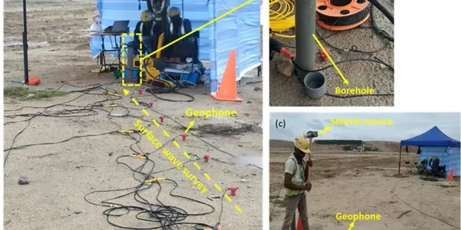
Process overview
Local context
Akron lies in a region of moderate seismic hazard: the USGS 2023 National Seismic Hazard Model assigns a PGA with 2 percent probability of exceedance in 50 years of roughly 0.06g to 0.08g for bedrock in Summit County. That number looks low, but it multiplies by a factor of 1.6 to 2.4 when soft soils amplify the motion. A building designed to a Site Class C spectrum that actually sits on Site Class E fill may be under-designed by 30 percent or more at short periods. The buried valley deposits also carry liquefaction potential where the water table is within 15 feet of the surface—common in the Merriman and North Hill areas. A seismic microzonation study identifies these pockets before the structural engineer locks in the base shear. For critical facilities such as Akron's water treatment plant on the Upper Cuyahoga, the IBC explicitly requires site-specific ground motion analysis when Site Class D or E is present, making microzonation not a research exercise but a code compliance step.
Reference standards
ASCE 7-22 Minimum Design Loads for Buildings and Other Structures, IBC 2024 Section 1613 Earthquake Loads, ASTM D4428/D4428M-14 Standard Test Methods for Crosshole Seismic Testing, ASTM D7400-19 Standard Test Methods for Downhole Seismic Testing, NCEER/NSF-95 Workshop on Liquefaction Resistance of Soils (Youd-Idriss)
Additional services
Site-Specific Response Analysis & Site Class Determination
A single-site study combining MASW or downhole shear-wave profiling with a geotechnical boring to measure Vs30 and classify the site per ASCE 7-22 Chapter 20. We construct a 1D soil column, run equivalent-linear or nonlinear site response using DEEPSOIL or Strata, and deliver design response spectra, amplification factors Fa and Fv, and a signed report suitable for permit submission. This scope satisfies IBC 2024 Section 1613.2 for Site Classes D and E where the default simplified procedure is not permitted.
Urban-Scale Microzonation Mapping
A multi-site campaign covering several city blocks or an entire facility campus. The workflow includes a dense grid of MASW and microtremor H/V measurements, targeted CPT soundings, and existing borehole log compilation. Results are interpolated in GIS to produce continuous Vs30 maps, Site Class polygons, peak ground acceleration contours, and spectral acceleration rasters at 0.2s and 1.0s periods. This package supports municipal planning, portfolio risk assessment, and campus-level resilience studies.
Typical parameters
Quick answers
What is the difference between the USGS hazard maps and a site-specific seismic microzonation study?
The USGS National Seismic Hazard Model provides ground motions at a reference rock condition. It does not account for local soil amplification beyond the generic site-class corrections in the code. A microzonation study measures the actual shear-wave velocity profile at the site, builds a soil column, and computes how that specific column filters and amplifies bedrock motion. In Akron, where the buried Cuyahoga Valley fill can change the site class over a distance of 200 feet, the site-specific spectrum often differs from the default code spectrum by 20 to 50 percent at short periods.
How much does a seismic microzonation study cost for a single building lot in Akron?
For a single-lot study in Summit County, costs generally range from US$3,770 to US$19,200 depending on the depth of the soil column, the number of shear-wave measurement points, and whether CPT or SPT borings are included. A basic Vs30 determination with one MASW line and a single boring falls toward the lower end; a full site response analysis with multiple profiles and liquefaction screening moves toward the upper end.
Does the City of Akron or Summit County require seismic microzonation for building permits?
Neither the City of Akron nor Summit County maintains a local seismic ordinance beyond the adopted State of Ohio Building Code, which references the IBC. The IBC requires site-specific ground motion analysis when Site Class D or E is present and the mapped spectral acceleration exceeds certain thresholds, or for structures assigned to Risk Category III or IV. In practice, this means that a site response study is code-mandated for many parcels in the Merriman Valley and the buried Cuyahoga corridor, as well as for essential facilities such as hospitals, emergency response centers, and water infrastructure.